Cass River
Greenway
Since 2007
  • Home
  • Video
  • About Us
    • Contact CRG
    • Who is the Cass River Greenway Committee?
    • Organizational Information
    • Partners
    • Publications, Reports, Presentations
    • Meeting Minutes >
      • 2024 Meetings
      • 2023 Meetings
      • 2022 Meetings
      • 2021 Meetings
      • 2020 Meetings
      • 2019 Meetings
      • 2018 Meetings
      • 2017 Meetings
      • 2016 Meetings
      • 2015 Meetings
      • 2014 Meetings
  • Cass River Blog
  • Recreation
    • Cass River Water Trail
  • Habitat
  • Water Quality
    • Watershed Maps and Resources
    • Our Watershed
    • Watershed Presentation
    • Report a Problem on the Cass
    • Cass River Water Quality Project Summary
    • Watershed Management Plan
    • Clean Water Act
  • Events

The Cass River Watershed

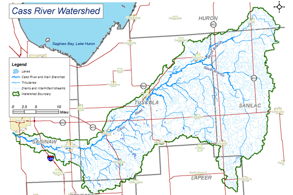
The Cass River Watershed encompasses an area of 908 square miles (approx. 578,812 acres), contains 1352 miles of rivers and streams and hundreds of miles of county drains.  The Cass River flows to the Saginaw River and eventually to Saginaw Bay.  Located in Michigan’s Lower Peninsulas Thumb Region the watershed includes portions of Genesee, Huron, Lapeer, Saginaw, Sanilac, and Tuscola counties.  Communities in the watershed include Bridgeport, Cass City, Caro, Frankenmuth, Marlette, Millington, Tuscola, Vassar, and Ubly.

More Watershed Resources
Picture
Powered by Create your own unique website with customizable templates.